 |
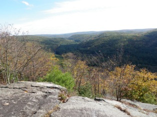
Jessie Gerard Trail (blue/yellow dot): At the East River Road trail-head, take the path to the right which passes by the historic Light House Village Graveyard site, and climbs up steep switchbacks. This path leads to the scenic overlooks, including Chaugham's Lookout.
The trail then passes between the Veeder Boulders, named for Curtis Veeder, an inventor from Hartford who helped raise money for Peoples Forest land purchases. The trail ends at the Big Spring Recreation Area. Distance - 1.3 miles. Jesse Gerard was a long-time director of the Connecticut Forest and Park Assoc. who enlisted the help of the Daughters of the American Revolution, and Connecticut Federation of Women's Clubs, to raise money for the Peoples Forest Fund. |
 |
Agnes Bowen Trail (blue/orange dot): The Agnes Bowen Trail is accessible from trail heads on Greenwoods Road and at the Nature Museum. This moderately hilly trail includes a scenic overlook, passes by the beaver marsh, and follows along Beaver Brook on the south side of Greenwoods Road. It features a boarkwalk into the beaver marsh, built in 2018 by FALPS, the Peoples Forest friends group. Distance - 2.5 miles.
As the secretary of the Barkhamsted Chamber of Commerce, Agnes Bowen was responsible for suggesting that the state locate the Peoples Forest in Barkhamsted. She then personally led a tour of officials on the proposed 2500 acre site that would eventually become the Peoples State Forest. |
 |
Charles Pack Trail (blue/yellow dot): The Charles Pack Trail starts at Greenwoods Road, north of the James Stocking Area. It crosses Beaver Brook and goes past the brick and stone remains of an early 1800s farmhouse. It then crosses the road at the Beaver Brook Recreation Area and continues on to the Big Spring Recreation Area. Distance - 1.9 miles. Charles Pack was president of the American Tree Assoc. and the American Nature Assoc. He was an early supporter of public forests and offered technical forestry advice which, among other things, helped save a beech tree grove along the Pack Grove Road. He also made generous donations to the PSF forestry fund. |
 |
Elliot Bronson Trail (blue/red dot): The Bronson Trail starts at Greenwoods Road just before the Ullmann Youth Camping area and runs through the hilly terrain of the southern portion of the forest. It terminates on Center Hill Road, off of route 181. Distance - 2 miles. E.P. Bronson wrote the Forestry Pageant for the dedication of Peoples Forest in 1924. He was also a forest fire warden, a member of the Board of Fisheries and Game, and Superintendent of State Parks until 1964. |
|
|
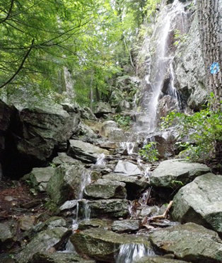
Falls Cut-Off Trail (blue/red dot): The trail-head is on East River Road and starts at the Jessie Gerard Trail sign. Follow this trail to the left. It is steep and rocky and features stone steps installed by the CCC in the 1930s. This trail is a popular winter ice-climbing site. Distance - .2 miles. |
 |
Robert Ross Trail (blue): The Ross trail starts at the end of Warner Road, runs westerly to the Jessie Gerard Trail; and then southerly along the west side of the ridge, to the end of King Road; proceeds to the Museum and westerly to East River Road. Distance - 2 miles. Robert Ross was a forester who sponsored the first Forestry Work Camp in the 1930s, which was later used as a model for the C.C.C. He was very influential in the development of Peoples Forest. |
 |
Walt Landgraf Trail (red): This trail starts near the east end of the Elliott Bronson Trail and leads to an area of rock ledges known as the Indian Caves. For 1500 years soapstone was quarried in this area by Native Americans. Distance - .2 miles. Walter Landgraf was the curator of the Nature Musuem (then called the Stone Museum) from 1992 when it reopened, until his passing in 2007. He is fondly remembered for his wealth of knowledge about the forest, its flora and fauna, and local history. |
 |
The Pond Trail (green): This scenic trail, created in the summer of 2012 by a seasonal State worker, ends at the beaver marsh. Birds and other pond life may be observed from here. To reach this trail, start at the southernmost Charles Pack trailhead on Greenwoods Road, follow it to the wooden bridge that crosses Beaver Brook, then take an immediate left and follow the green markers. Distance - .1 miles. |